Remembering the eruption of Mount Saint Helens. Thirty-two years ago yesterday on May 18th, one of the biggest natural disasters that has ever occurred in the history of the State of Washington took place. The events of the eruption still holds a fascination for me even after all these passing years. In honor of those who perished, and who undoubtedly are still missed by their friends and loved ones, I dedicate today’s post.
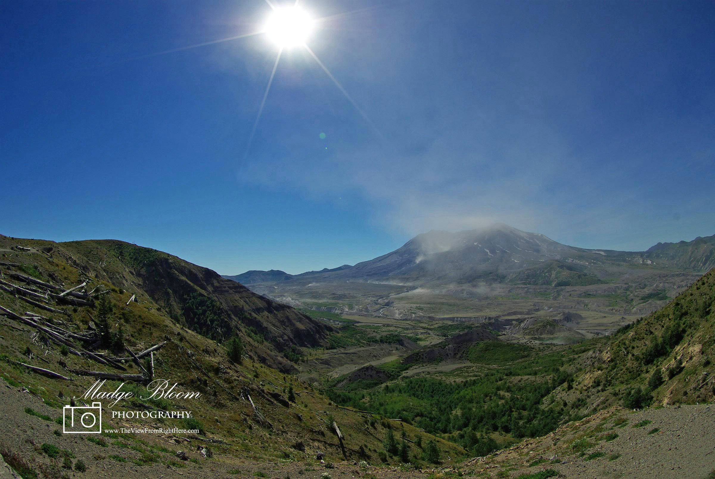
Most of the forested hills along the Toutle River were planted about 25 years ago. The land within the Mount St. Helens National Monument was left to recover ‘naturally.’ Within the monument area, you can clearly see the blow-down area and the area where the debris flowed into the Toutle. It is still an amazing place.
Mount Saint Helens - Blow Down Area - Click Photo for Enlarged ViewMt. St. Helens erupted at 0832 on May 18, 1980 triggered by a 5.1 earthquake and blew 1300 feet off the top of the mountain. David Johnston, a USGS geologist who was on a ridge six miles from the mountain monitoring it’s activity, sent this radio message to Vancouver, WA (they were his last words, he perished) “Vancouver! Vancouver! This is it….” With those words—tinged with excitement rather than panic, hearers said, announced the end of calm and the start of cataclysm.
Pre 1980 Eruption - Mount Saint Helens - Public Domain ImageLater an observatory was built on a ridge overlooking the crater, both the ridge and observatory stand as a memorial to his work, both bear his name, Johnston. At the time I lived in Kent, about a two hour drive from the mountain. The sound of the eruption woke me up on that Sunday morning. On the occasion of several of the subsequent eruptions, my place received a dusting of ash which looked like a heavy winter frost. Then later when it rained, it looked like running milk down your windows and over your car. At the Port of Seattle, where I worked at the time, we had ‘Emergency Eruption Stations,’ filled with masks and supplies if we needed them in the event of a huge eruption that fanned the plume into Seattle. During one of the earlier subsequent eruptions, as I was driving home from work one afternoon on Interstate 5 in the SeaTac area, the weather was clear and you could see the massive plume over 100 miles away. People were so mesmerized by the sight that traffic stopped in the middle of the freeway and people were out of their cars gawking.
USGS Photo of Eruption on May 18, 1980 - Public Domain ImageFifty seven people were killed in the eruption and it devastated 230 square miles of forest, ripping trees out of the ground as far as 17 miles from the volcano. One survivor was David Crockett, 28, a photographer with KOMO News 4, he was at the base of the mountain on a logging road in a truck. At the moment of the eruption he looked up and saw a wall of mud coming towards him. His location on the road was such that the mud flow split into two ‘rivers’ and flowed around him. He drove a short distance and the road was washed out. He got out of the truck, taking his video camera with him and began stumbling towards a small patch of light on the horizon, this is what he recorded that day as he fought to live: “I am walking toward the only light I can see. I can hear the mountain rumble. At this very moment I have to say, ‘Honest to God, I believe I am dead.’ The ash in my eyes burns my eyes, burns my eyes! Oh dear God, this is hell! It’s very, very hard to breathe and very dark. If I could only breathe air. God, just give me a breath! I will try the radio. Mayday! Mayday! Ash is coming down on me heavily. It’s either dark or I am dead. God, I want to live!” He was rescued 10 hours later and his six minute video has become a classic piece detailing the eruption.
Just one last note of interest, my girl friend and I had made several trips down to look at the mountain prior to the initial eruption on May 18th, we made plans to go camp at the Toutle River Campground the very weekend of the first eruption, but it was either my work schedule or hers that prevented us from being in the midst of that disaster. Some who were camping at that location survived, some did not. I am thankful for the Lord’s providence that kept us out of harm’s way. (Clicking on any image – including the featured image gives an enlarged view).
Thanks for joining me today, for the view that is right here! ~ Madge
It’s time for you to enter your photos in ‘Weekly Top Shot – #31.’ ‘Weekly Top Shot’ is open to everyone and is not themed. Pick one of your posts that pleases you most and share it with us! The linky is open every Saturday morning by 09:00 Pacific Standard Time and will close the following Friday evening at 23:59.
Here’s how to join the meme and share:
Your post must be family friendly, one post per week please.
Submit the url of your blog post, not your home page.
Google+ users – submit the url of your posted photo on G+.
To link up – use the LinkyTools prompt below.
Include the ‘Weekly Top Shot’ badge, or a link to my post in your blog post.
Please visit some of other entries and leave encouraging comments.
(Permalink to create a text link back to this post: http://www.theviewfromrighthere.com/blog/?p=713)
What an AWESOME thing….thanks so much for sharing these photos.
And, thank you for hosting. This is my first time here and I am excited to share MY photos, too. :)
I traveled throughout WA on business in May of 1982. My visit to Mt. St. Helens was one of the most powerful I’ve ever had. The feeling of loss was still palpable as only the stoutest of plants had begun to grow. To see these pictures of what the blown out section looks like is incredible. Hundreds of trees floated atop Spirit Lake looking like so many toothpicks. Thank you for sharing your story and these stunning photos of how the mountain is thriving.
thank you for hosting .. and that’s a great post .. nature is fierce
Ruth Hiebert
I remember well that day and the days to follow. It was several days later when we,in Manitoba saw a grey cloud coming in from the west. When it was upon us,we realized that this was fallout from the Mt.St. Helen’s volcano.It left everything coated with a layer of very fine grey dust.
Great post, Madge. I remember that eruption and following its progress through the news. It must have been very upsetting to be right in the midst of it. Amazing set of circumstances that prevented you from being in the area while camping.
Excellent post on Mount St Helens, Madge. You had good fortune on that postponed camping trip!
I had left Seattle the night before heading north to Alaska on a fishing boat. My family in nearby Pacific County all fine, but had to deal with the ash problems for some time.
I remember that day well. I was living in Newberg, Oregon and we were coated with ash. It got into the engines and bearings of all the farm machinery and ruined a lot of equipment. We could see the plume from our home. I took a Greyhound bus to see my parents in Washington 4 days later and crossed the Toutle River. Giant logs were jammed every which way against the bridges of I-5 like a giant box of toothpicks were dumped out, and heavy equipment was moving giant piles of ash out of the river. Surreal.
Wow Madge. Stunning photo!! My 4year old son has been watching the same documentary about the eruption this past few weeks and I cannot wait to show him your happy photo of the mountain twentytwo years later!
Madge I also have been intrigued by Mt St Helens over the last few decades. Every now and then I get our my Nat Geo’s from the event.
Spectacular images. Sorry to hear your not well. Hope you recover soon.
is it soo long ago now? It still feels like maybe 10 or so. Even if I live in Sweden I still remember the event. Love the shots and it is a great post.
Hope you are well. :)
I vaguely remember the eruption of Mount St. Helens when I was in elementary school. It was on the news for days. It was a really big event and more than anything, I recall the news footage of the huge ash cloud. Your photo is beautiful and eerie at the same time! I hope you’re fully recovered and feeling good again soon, Madge!
Hi there – we drove to the top of M St H many years ago (after it had erupted) and all we saw was clouds! We kept saying “will get above the clouds soon” – but we never did. Thanks for showing what we missed!
Beautiful photo Madge. I remember that day…Hubby and I had gone to Kamloops British Columbia with our 3 month old daughter to celebrate our anniversary. What a shock when we turned the TV on and heard the news. Hard to believe it was that many years ago. Thank heavens you and your friend didn’t go camping that weekend. I hope this weekend has been a good one so far. Maura
Superb shot of Mt. St Helens Madge, it sounds like you had a very lucky escape from what could have been a disastrous time. Wonderful view of the valley. Keep well.
Great post Madge, hard to believe it was that long ago! My older brother lived fairly close by back then and he still talks about the ash coating everything.
Glad they finally figured out what was wrong with you and hope you start getting better soon!
It is weird to think it has been 32 years. I had family that lived up there and we had went hiking up there years before.
It is nice to see how it is now. I am so sorry you have been sick. I hope you feel better soon. I have a friend who caught it too and it took her a long time to get well.
Take care of yourself.
Incredible view! My hubs & I talk about this a lot. He was living in central CA at the time & he remembers it raining ash all the way where he was when it happened. Incredible how powerful the Earth is –
Sorry to hear you have been under the weather- hope you are improving now.
A fine retrospective documentary series of Mt. St. Helens fateful explosion. Out in the scab-land south of here, I still see ash on the surface among the sage brush after all this time.
Barb Farr
Sorry to hear you have been I’ll, Madge. Hope you are feeling better soon.
I remember the morning Mt Saunt Hrlens erupted. I was living in Colorado and I went out to a car covered in volcanic ash. Nature is amazing and occasionally destructive thank for sharing your story.
WOW, what a story… I so enjoyed this post — very informative and the photographs are stunning. Thankyou for sharing.
Im blog hopping over from A Rural Journal – Sunday Best. Great to find your blog… I shall be reading more.
Jennie. x
I remember the day well. We were are an air show in Sandpoint, Idaho, and while driving home, crossing the bridge on highway 95, the ash rolled in like a thunderstorm, only much lower. We found out after returning home what had happened.
We were spared the worst of the ash fall, and only had a film of dust on everything.
It was such a tragedy. I remember all the coverage. My uncle used to be able to see the mountain from his home until the eruptions. Beautiful post to honor those that lost their lives.


i cannot imagine what that must have been like – to perish in it or to survive it. mother nature at its most powerful.
What an AWESOME thing….thanks so much for sharing these photos.
And, thank you for hosting. This is my first time here and I am excited to share MY photos, too. :)
Thanks BJ for coming over to share!
A gorgeous shot. I remember when that happened and thinking how awful it must be for the effected people and nature.
Wow, I can’t even imagine! Sad and crazy mother nature can be!
Thank you for sharing and hosting the party!
That had to be scary for everyone, and thanks for the information. What a great way to remember those who lost their lives!
A gorgeous, wide, super shot ..
Best regards, Karin
That is so amazing, I wasn’t in this world yet when it happened. Thank you for sharing it today.
Your photo is amazing!!!!!
That’s really fascinating…and I love your shot!
I traveled throughout WA on business in May of 1982. My visit to Mt. St. Helens was one of the most powerful I’ve ever had. The feeling of loss was still palpable as only the stoutest of plants had begun to grow. To see these pictures of what the blown out section looks like is incredible. Hundreds of trees floated atop Spirit Lake looking like so many toothpicks. Thank you for sharing your story and these stunning photos of how the mountain is thriving.
Hi darling…have a nice weekend……love from me……xxx…
Amazing shot,thanks for hosting :)
thank you for hosting .. and that’s a great post .. nature is fierce
I remember well that day and the days to follow. It was several days later when we,in Manitoba saw a grey cloud coming in from the west. When it was upon us,we realized that this was fallout from the Mt.St. Helen’s volcano.It left everything coated with a layer of very fine grey dust.
I remember hearing about this when I was in high school.
wonderful photos… thanks for sharing those amazing stories
Great post, Madge. I remember that eruption and following its progress through the news. It must have been very upsetting to be right in the midst of it. Amazing set of circumstances that prevented you from being in the area while camping.
Thank you for hosting this lovely meme.
Excellent post on Mount St Helens, Madge. You had good fortune on that postponed camping trip!
I had left Seattle the night before heading north to Alaska on a fishing boat. My family in nearby Pacific County all fine, but had to deal with the ash problems for some time.
An amazing event, to be sure. Excellent post, Madge.
I remember that day well. I was living in Newberg, Oregon and we were coated with ash. It got into the engines and bearings of all the farm machinery and ruined a lot of equipment. We could see the plume from our home. I took a Greyhound bus to see my parents in Washington 4 days later and crossed the Toutle River. Giant logs were jammed every which way against the bridges of I-5 like a giant box of toothpicks were dumped out, and heavy equipment was moving giant piles of ash out of the river. Surreal.
Surreal.. yes it was that!
Unbelievable shot. You are so talented. Hope you feel a little better!
Twenty-two years later, it is as beautiful as before.
Wow Madge. Stunning photo!! My 4year old son has been watching the same documentary about the eruption this past few weeks and I cannot wait to show him your happy photo of the mountain twentytwo years later!
32 years! Seems like yesterday. Your top shot is awesome, and I like the write-up too!
Madge I also have been intrigued by Mt St Helens over the last few decades. Every now and then I get our my Nat Geo’s from the event.
Spectacular images. Sorry to hear your not well. Hope you recover soon.
is it soo long ago now? It still feels like maybe 10 or so. Even if I live in Sweden I still remember the event. Love the shots and it is a great post.
Hope you are well. :)
I vaguely remember the eruption of Mount St. Helens when I was in elementary school. It was on the news for days. It was a really big event and more than anything, I recall the news footage of the huge ash cloud. Your photo is beautiful and eerie at the same time! I hope you’re fully recovered and feeling good again soon, Madge!
Hello darling…i hope you feeling better soon…..take good care of yourself….love from me….xxx..
Delicious sunlight. I love this landscape.
Hi there – we drove to the top of M St H many years ago (after it had erupted) and all we saw was clouds! We kept saying “will get above the clouds soon” – but we never did. Thanks for showing what we missed!
Stewart M – Australia
Beautiful photo Madge. I remember that day…Hubby and I had gone to Kamloops British Columbia with our 3 month old daughter to celebrate our anniversary. What a shock when we turned the TV on and heard the news. Hard to believe it was that many years ago. Thank heavens you and your friend didn’t go camping that weekend. I hope this weekend has been a good one so far. Maura
I’ve been there twice… each visit getting closer. Amazing images. I remember the first trip… trees down like matchsticks.
Superb shot of Mt. St Helens Madge, it sounds like you had a very lucky escape from what could have been a disastrous time. Wonderful view of the valley. Keep well.
Great post Madge, hard to believe it was that long ago! My older brother lived fairly close by back then and he still talks about the ash coating everything.
Glad they finally figured out what was wrong with you and hope you start getting better soon!
Great shot and interesting info!
Very interesting set of photos and information, Madge. Thanks for hosting!
It is weird to think it has been 32 years. I had family that lived up there and we had went hiking up there years before.
It is nice to see how it is now. I am so sorry you have been sick. I hope you feel better soon. I have a friend who caught it too and it took her a long time to get well.
Take care of yourself.
I remember it as well. Devastating!
V
Incredible view! My hubs & I talk about this a lot. He was living in central CA at the time & he remembers it raining ash all the way where he was when it happened. Incredible how powerful the Earth is –
Sorry to hear you have been under the weather- hope you are improving now.
I remember the place, good to see it again harmless and beautiful…
A fine retrospective documentary series of Mt. St. Helens fateful explosion. Out in the scab-land south of here, I still see ash on the surface among the sage brush after all this time.
Sorry to hear you have been I’ll, Madge. Hope you are feeling better soon.
I remember the morning Mt Saunt Hrlens erupted. I was living in Colorado and I went out to a car covered in volcanic ash. Nature is amazing and occasionally destructive thank for sharing your story.
I meant ill. Darn auto correct.
An event we all remember. What a gorgeous shot of yours. Amazing to see the lack of trees – still, and the downed ones still there.
WOW, what a story… I so enjoyed this post — very informative and the photographs are stunning. Thankyou for sharing.
Im blog hopping over from A Rural Journal – Sunday Best. Great to find your blog… I shall be reading more.
Jennie. x
I remember the day well. We were are an air show in Sandpoint, Idaho, and while driving home, crossing the bridge on highway 95, the ash rolled in like a thunderstorm, only much lower. We found out after returning home what had happened.
We were spared the worst of the ash fall, and only had a film of dust on everything.
I’m so happy you were spared!
Wonderful post! I have fond memories of our family vacation to Mount St. Helens!
Wonderful photos…
Thank you for sharing this story!
It was such a tragedy. I remember all the coverage. My uncle used to be able to see the mountain from his home until the eruptions. Beautiful post to honor those that lost their lives.
I remember this event. This is a nice memorial to those who perished then.